Spring 2011 Disaster Planning – Selected Student Projects
The course project asked students to use Google Map to present hazards related information in comprehensible and usable forms. The objective of this assignment was to challenge students to synthesize material from the course and present it in a way that was meaningful to them and useful to the community. Google Map is freely accessible through any web browser. Mash-ups in Google Map use images and tags for simple maps, or combined with other Application Programing Interface (API), such as Twitter, Flickr, Facebook, You Tube, to create more complex Mash-ups. Students could choose how to make their own Mash-up. They were required to use all the information they could cull from this class – lectures, discussions, readings, videos, guest talks, field trip – to synthesize an aspect of Emergency Management (emergency preparedness, emergency response, disaster recovery, or hazard mitigation) in a way that applied to Pitt County or the City of Greenville in North Carolina, and present this information through a Mash-up.
AMY SHEW & JENNY MILLS – RISKY SWINE FARMS IN PITT COUNTY, NORTH CAROLINA

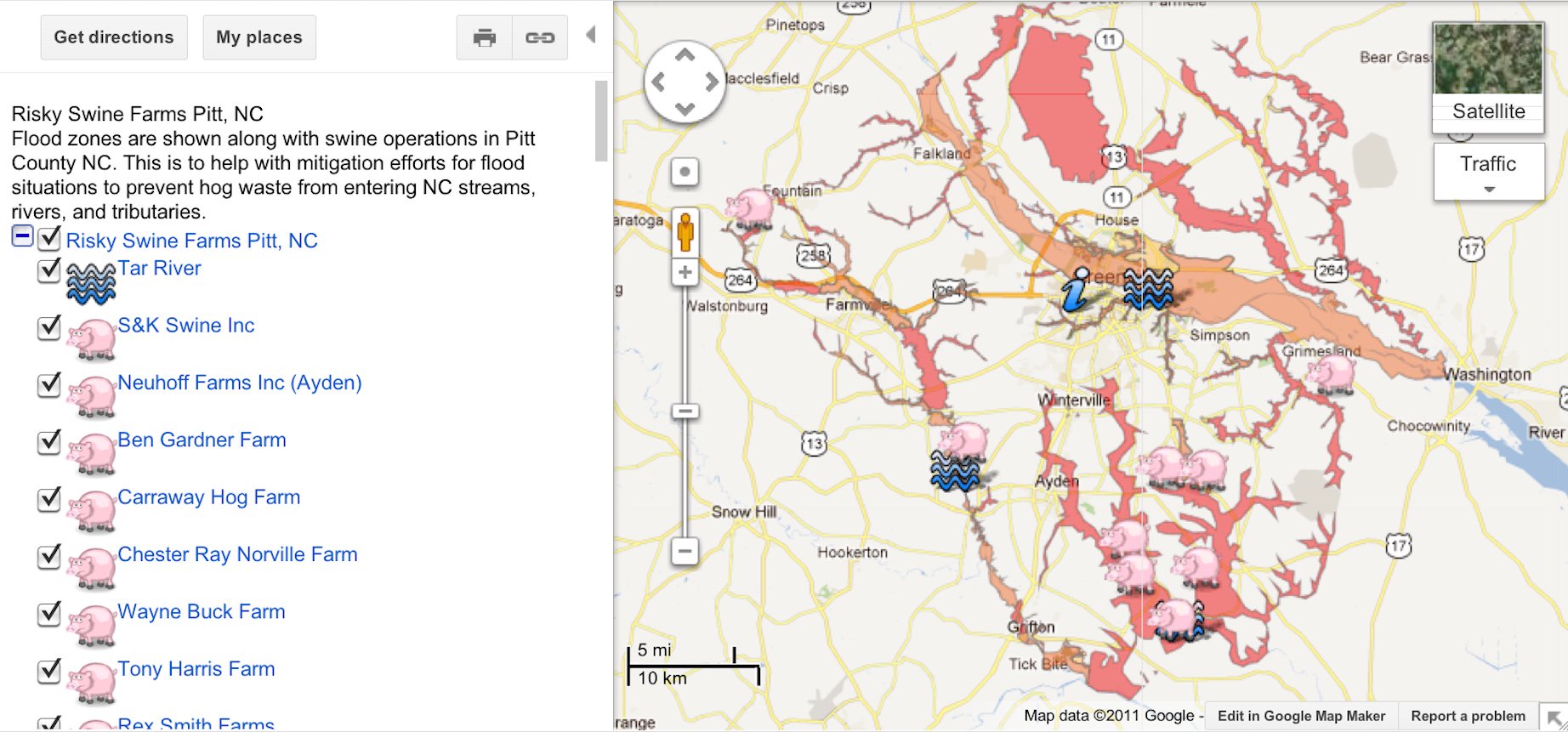
Project Description: Flood zones are shown along with swine operations in Pitt County NC. This is to help with mitigation efforts for flood situations to prevent hog waste from entering NC streams, rivers, and tributaries.
Through out the course of this semester, mitigation strategies and hazards have been examined from many different angles. Through the evolution of this course my original project ideation of risk mitigation in flood situations for Pitt County has took an environmental turn and led me to examine animal operations that are located within the flood plain of Pitt County.
This project compiles two technologies to create a user friendly map. The first technology used was Geographical Information Systems (GIS). GIS was used to incorporate flood zone, and animal operation data into a Google Map. I selected only animal operations that were located within flood zones, all of these animal operations were swine farming operations. GIS allowed me to use latitude and longitude to pin point the location of these swine farms, otherwise I feel it would have been practically impossible to locate these farms. Farm owners seem to be very secretive about the location of their facilities. Therefore this Google Map focuses on swine farming operations in Pitt County that are located within the flood plain.
One objective of this project is to educate others by showing them where these risky swine farms are located, and the potential impacts associated with hog farms that are located in the flood zone. The Google Map is also intended to be used as a tool to gain community support for another objective. New regulations state that “No component of manure management system within 100 year floodplain” (NC Pork Council). How is it then that these farms are still able to operate? It is understood that swine farms make up a large percentage of eastern North Carolinas economy but at what cost to the people living here? These operations would be too expensive for an ordinary farmer to move without incentives or help from the government, but many of these farms are owned by large companies such as Smithfield. If Smithfield was told they had to move these farms they could possibly just relocate to a different state causing economic hardships for many North Carolinians. The main objective that would be easier to accomplish with community support, would be to relocate all hog farms that are located within the 100 year flood zones. This Google Map can be used as a beginning tool, to show how important it is that these farms are relocated. By using Google Maps, I have created an interactive and informative educational tool for a variety of users, with a purpose of helping to relocate risky swine farms in Pitt County NC.
This Google- Map has been created for a variety of users. It can be used by everyday citizens to educate themselves on risky hog farms. It could also be used as a presentation piece, shown to local government officials in attempts to find a means to relocate these selected swine farms. This map can help all of these individuals as it is a data rich source. The map shows nine hog farms all of which are located within the flood plain. When one clicks on the icon denoting hog farms a text box pops up in this text box there is information about the owner of the hog farm, the design capacity of the farm, the total weight of animals at the farm, and a description of the hogs at the farm. There is also an aerial picture of each farm taken form Google Earth. Several farms in particular has a link to more photos which were taken by me, in some of the photos one will see the hog farm, a stream located by one of the farms, and numerous posted and no trespassing signs. None of the photos take by me show hog lagoons, lagoons are well out of view from the road, and the only way to get a picture would be to trespass. There is also and information icon which brings up links to multiple resources, such as a student presentation by Wyatt Thrope on the Health Effects of Hog Farms. There are other links to items such as: permit information for hog farms, a video tour of a hog farm, an informational virtual tour from beginning to end of hog operations, photos from hog farm flooding during hurricane Floyd, and NC pork council regulations. All of these links are useful and very informative. It is a very strong educational tool, and should be helpful in the process of trying to relocate hog farms. While relocation may be expensive this mitigation strategy could greatly reduce environmental and health risks associated with flooded hog farms.
JESSICA RUSSELL – FLU VACCINATION CLINICS IN GREENVILLE, NORTH CAROLINA

View FLU VACCINATION CLINICS IN GREENVILLE, NORTH CAROLINA in a larger map
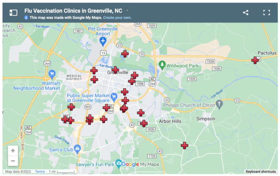
Project Description: Unlike the plan currently in place, which primarily uses local schools as vaccination sites, this emergency plan utilizes Greenville’s voting precincts, commonly known locations to citizens, as vaccination clinics, thereby allowing for quicker clarification of each citizen’s assigned clinic and a more organized and even distribution of people. The Pitt County Public Health Department will hire nursing staffs for each clinic and maintain vaccination records with the NC Immunization Registry. At each clinic, citizens will be educated by a Public Health official on the virus and receive the flu vaccination.
This mash-up has been specifically designed for the citizens of the city of Greenville, North Carolina in the event of an extreme flu outbreak. During such an event, the sick will be at local doctor’s offices and the Pitt County Memorial Hospital, therefore demanding the implementation of “vaccination clinics” within the community to protect its uninfected citizens. The emergency plan currently in place uses local schools as the vaccination clinics, thus not only disrupting school, but also putting susceptible children at risk for contracting the potentially deadly virus. This revised emergency plan utilizes Greenville’s voting precincts as the vaccination clinics, which are commonly known locations to citizens and therefore allow for quicker clarification of each citizen’s assigned clinic and a more organized and even distribution of people. The assigned precincts are places of ample parking and inside room to accommodate a large volume of people and a wide spectrum of ages. (There will be approximately 3,676 people assigned to each clinic.) This mash-up seeks to provide a clear and informative visual aid to clarify the location and specific information of the designated clinics to their assigned citizens. It also provides helpful and informative websites for local government and news information, along with educational videos about the influenza virus and how to protect oneself.
The Pitt County Health Department will be the official government branch in charge of the plan, and thus responsible for hiring a nursing staff for each clinic and maintaining vaccination records with the NC Immunization Registry. Due to ongoing shipments of the vaccine to the Pitt County Health Department, the vaccinations will be given several days a week until all Greenville citizens have received their vaccine. Volunteers, such as retired nurses and county health officials, will be stationed at each clinic to match people arriving to those on their list for that specific vaccination location, relay information, and provide a sense of stability and calmness. While people wait at the vaccination clinics, they will be educated by the nurses with flyers and brief videos, but also by an educated and specifically trained official giving a continuously repeated speech concerning the vaccine and the virus, thus ensuring that the public has the opportunity to be as knowledgeable and informed as possible. Also, to assist those without personal transportation, once the County Commissioners deem it an emergency, Pitt Area Transit will suspend regular transportation and set up “emergency transportation” routes to assist in maintaining organization and equal opportunity for vaccination among citizens.
Citizens must know which clinic they are assigned to, for each location will receive only a specific number of doses of the vaccine to cover those assigned to that particular clinic/precinct. For those who are unaware of their assigned voting precinct, they may find this information on the Pitt County government website listed on the mash-up page. People showing up at unassigned vaccine locations can receive the vaccine, but the clinics must communicate with each other to document who has been vaccinated. As well as on the mash-up site, maps of the assigned clinics for vaccines will be on the Pitt County Public Health’s website; PittTv, Greenville’s PEG channel; and available on the local news channels, newspapers, and announced on local radio stations in both English and Spanish. In addition, the EOC call lines will be open and ready for concerned citizens to call in with their questions.
Upon such an outbreak, the immediate implementation of this emergency plan would provide vaccinations in a safe, organized, and efficient manner to Greenville citizens so that the virus could not continue to rampantly spread. This mash-up provides an organized and informative map of the voting precincts, turned vaccination clinics, along with essential data and helpful local government and news websites, furthering the possible knowledge with which the citizens of Greenville can arm themselves to combat the spread of the flu virus.